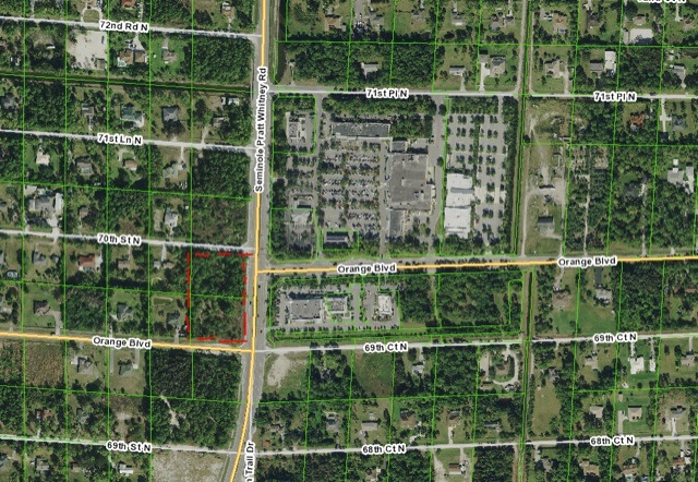
I wrote yesterday about an application submitted to the County for a 7Eleven. Today, I want to share with you the details and how these changes come about so you understand the full implications to our community. Many people have asked over the past couple of years, "how did Westlake happen?" or "how did Minto get approved?" Let me tell you how!
It starts with a privately initiated text amendment to the Comprehensive Plan, usually made by developers and sometimes supported by County staff, to allow uses in a specific area or designation that is now currently prohibited. Once the County approves the text amendment to the Comprehensive Plan, now it allows for a specific application for land use change on a property, which use is previously prohibited. Once land use change is obtained, now a zoning application is completed to allow the project. In most cases, these applications and amendments run concurrently.
Regarding the 7Eleven application at the corner of Seminole Pratt Whitney and Orange, this is what the first phase of the application (Comprehensive Plan Text Amendment) states:
"The purpose of the overall application is to provide for the development of neighborhood scale commercial at an established major intersection where a CRALLS Intersection designation has been previously established as follows:
1. Amend the language in Policy 1.3-f to create a new “Commercial Node” criteria to provide for new Commercial Low future land use designation at the intersection of an Arterial Road and Collector Road which contains an active CRALLS Intersection designation as listed on Map TE 15.1."
This text amendment to the Comprehensive Plan has far reaching implications throughout our community. Immediately, it would allow land at the following corners to be changed to commercial low (convenience stores, gas stations, etc.) properties that are currently agricultural residential land use:
- Northlake and Seminole Pratt Whitney;
- Northlake and Coconut (South side already approved for commercial);
- Orange and Coconut;
- Orange and Royal Palm Beach Blvd.;
- Orange and Seminole Pratt Whitney west side;
- Royal Palm Beach Blvd. and 60th;
- Royal Palm Beach Blvd. and Persimmon;
- SR7 and 60th;
- SR7 and Persimmon;
- 140th Avenue and 60th;
- 140th Avenue and Persimmon;
The above list only looks at existing roads that are designated on the County's Thoroughfare map, MAP TE 15.1. Please note that several of these roads (Orange Blvd. west of Seminole Pratt Whitney, 140th Avenue and Persimmon Blvd.) the County does not have easements or Rights of Way to and they are not deemed County Roads even though they are on the County's Thoroughfare Map.
I need to get ready for a meeting, so more commentary later.
 I wrote yesterday about an application submitted to the County for a 7Eleven. Today, I want to share with you the details and how these changes come about so you understand the full implications to our community. Many people have asked over the past couple of years, "how did Westlake happen?" or "how did Minto get approved?" Let me tell you how!
It starts with a privately initiated text amendment to the Comprehensive Plan, usually made by developers and sometimes supported by County staff, to allow uses in a specific area or designation that is now currently prohibited. Once the County approves the text amendment to the Comprehensive Plan, now it allows for a specific application for land use change on a property, which use is previously prohibited. Once land use change is obtained, now a zoning application is completed to allow the project. In most cases, these applications and amendments run concurrently.
Regarding the 7Eleven application at the corner of Seminole Pratt Whitney and Orange, this is what the first phase of the application (Comprehensive Plan Text Amendment) states:


